Data Foundation
Manage optical satellite imagery, SAR, hyperspectral scenes, video streams, DEM/DOM products, vectors, and IoT observations in one place.
View data assetsMulti-Source Sensing · Massive Aggregation · Intelligent Interpretation
Integrating satellite, aerial, UAV, and ground observation data, this portal covers data management, AI interpretation, industry applications, thematic services, and result publishing for land, ecology, coastal monitoring, urban planning, and emergency response workflows.
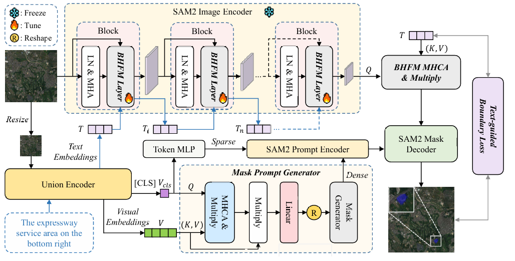
Platform Overview
The site is structured around four layers: data foundation, algorithm platform, operational scenarios, and publishing and sharing.
Manage optical satellite imagery, SAR, hyperspectral scenes, video streams, DEM/DOM products, vectors, and IoT observations in one place.
View data assetsProvide detection, change analysis, semantic segmentation, time-series monitoring, sample management, and model training and deployment.
View algorithm platformSupport farmland supervision, forestry surveys, river inspection, coastal monitoring, urban diagnostics, and disaster response.
View application scenariosRelease thematic layers, data APIs, analytics reports, large-screen views, and rapid intelligence bulletins through one coordinated portal.
View latest updatesCore Capabilities
Bulk satellite onboarding, metadata governance, tiling, pyramids, and quality assurance.
Reusable and traceable model services for targets, land cover, damage assessment, and temporal change.
Rapid production of land use, ecological redline, crop condition, water distribution, and impact assessment maps.
Detect abnormal parcels, illegal occupation, suspected hotspots, channel deformation, and high-risk zones.
Deliver portal access, APIs, map services, reports, and task subscriptions in parallel.
Enable shared layers, task routing, result review, version control, and audit trails across departments.
Operational Scenarios
Support land-space monitoring, land use updates, mine restoration oversight, suspected illegal occupation screening, and field verification.
Open scenarioFocus on vegetation cover, water eutrophication, ecological protection zones, urban heat, and carbon sink analysis.
Open scenarioSupport crop condition analysis, sown area estimation, non-agricultural conversion monitoring, pest identification, and yield assessment.
Open scenarioQuickly delineate impacted zones, access conditions, and risk areas for floods, landslides, fire events, typhoons, and earthquakes.
Open scenarioOpen Resources
Static Assets
The buttons below are presentation-only and do not trigger file downloads.
GeoTIFF sample tile shown as a static portal asset.
GeoTIFF sample tile displayed for catalog demonstration only.
GeoTIFF sample tile kept as a non-interactive reference item.
News and Releases
Thematic Bulletin
New quarterly water boundary layers, suspected shoreline encroachment polygons, and analysis graphics are now available.
View detailsPlatform Upgrade
Users can submit multi-temporal batch jobs and automatically produce change surfaces, anomaly lists, and comparison maps.
View featureIndustry Use Case
The portal now supports inspection, verification, evidence collection, remediation tracking, and progress feedback in one chain.
View scenarioResearch Partner
A fictional branch profile for presentation use on the public homepage.
The Singapore branch of the American Geographic Systems Laboratory is presented as an interdisciplinary research center focused on Earth observation systems, geospatial AI, tropical climate mapping, coastal monitoring, and urban environmental intelligence.